Gallery

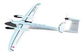
Snapshots of our precision surveying equipment in action

Survey-grade GNSS system set up on a tripod against a clear blue sky in Port Moresby
High-tech lidar scanner capturing detailed terrain data in a rugged outdoor environment
Drone hovering over a construction site performing aerial photogrammetry mapping
Close-up of a survey drone’s camera and sensors ready for a mapping mission

Trusted Surveying Experts

At jm & sons limited, we deliver precise surveying, drone mapping, and GIS services tailored to Papua New Guinea’s unique landscapes and industries.

Surveyor using GNSS equipment on a lush Papua New Guinea hillside at sunrise

10+

15

100+ Projects

10+ Years